Velika-Mala Cyclotourist Route
15/03/2021, 09:44According to the operational plan for the Varaždin County cycling tourism development, one of the project proposals is to achieve greater connectivity through the creation of a network of county bicycle routes.
A document entitled “Preliminary design of bicycle routes in the Varaždin County” was prepared, within which “unmarked” bicycle routes were mapped, traced, and detailed by the working names “External”, “Horizontal”, “Vertical 1” and “Vertical 2”. Previously marked routes together with unmarked ones form a functional network of county bicycle routes, which are accessible from all directions and thus achieve interstate, inter-county and intra-county connections.
The development of cycling tourism in the area of Varaždin County, based on the Ministry of Tourism program, is directed in 2019 towards the producing of a traffic study and equipping the “External” bicycle route with traffic markings.
The mentioned route is then given the tourist name Velika-Mala route and was designed as the basis of inter-county and inter-state connections for the reason that it starts and connects the far east, west, and south of the county. The Velika-Mala cycling route is named after the places from which the route starts, Veliki Lovrečan in the west and Mali Bukovac in the far eastern part of Varaždin County.
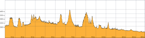
Velika-Mala route, elevation profile
Altitude profile in tabular preview of the Velika-Mala route:
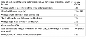
From the above table it can be concluded that throughout the entire route every 4.35 km of flat area or downhill, there is 1.58 km of ascent, with an average of 3.73% slope. The possibility of error of this calculation is not more than 5.6% concerning the total length of the route.